

|
TROPICAL WEATHER OUTLOOK
800 PM EDT Tue Jul 14 2026
For the North Atlantic...Caribbean Sea and the Gulf of America:Tropical cyclone formation is not expected during the next 7 days. TROPICAL WEATHER DISCUSSION
Tropical Weather DiscussionNWS National Hurricane Center Miami FL0015 UTC Wed Jul 15 2026Tropical Weather Discussion for North America, Central AmericaGulf of America, Caribbean Sea, northern sections of SouthAmerica, and Atlantic Ocean to the African coast from theEquator to 31N. The following information is based on satelliteimagery, weather observations, radar and meteorological analysis.Based on 1800 UTC surface analysis and satellite imagery through 2300 UTC
.TROPICAL WAVES A tropical wave is analyzed in the far eastern Atlantic along 21W, south of 18N, moving westward at 10-15 kt. Scattered to numerousmoderate to strong convection is seen from 05.5N to 13N and E of 27W .MONSOON TROUGH/ITCZ The monsoon trough enters the Atlantic through the coast ofMauritania near 18N16W and continues southwestward to 07N40W. TheITCZ then continues from 07N40W to the coast of Brazil near 01.5N50W. Convection near both features is described above withthe tropical wave .GULF OF AMERICA A stalled frontal boundary draped across the southern and southeastern United States, from eastern Texas to near theGeorgia-South Carolina border. An east to west upper trough acrossthis same area is combining with plenty of low level moisture anddiurnal heating to support scattered moderate isolated strong convection across much of the northern Gulf waters north of 27N. A surface coastal trough from the western Bay of Campeche to nearTampico supports scattered moderate convection across the far SW Gulf. Outside of convection, the Atlantic ridge extends across Florida and into the central Gulf. This pattern is supporting moderate to fresh NE-E winds and moderate seas off Yucatan and in the Bay of Campeche. Moderate winds and moderate seas are occurring north of 29N. Elsewhere, moderate or lighter winds and slight seas prevail.For the forecast, a stationary front will prevail just N of the area through midweek, enhancing thunderstorms across the northern Gulf waters. Mariners can expect gusty winds, frequent lightning, and locally higher seas near the stronger thunderstorms. Fresh to strong easterly winds will pulse offshore the Yucatan Peninsula each night. Elsewhere, gentle to moderate winds will prevail. CARIBBEAN SEA The pressure gradient between the persistent subtropical Atlantic ridgeanchored north of the islands along 26N-27N and lower pressures in northern South America continue to support strong to near gale-force easterly winds and rough seas to 11 ft in the south-centralCaribbean. Fresh to strong NE-E winds and moderate to rough seas are occurring in the remainder of the central Caribbean, Windward Passage and the Gulf of Honduras. Meanwhile, moderate to fresh easterly winds and moderate seas are noted in the eastern Caribbean, the Windward Passage, and the Gulf of Honduras. Elsewhere, moderate or weaker winds and slight to moderate seas are prevalent. Scattered moderate to strong convection covers thearea between the W coast of Jamaica and the Gulf of Honduras, andis strongest along the NE coasts of Honduras and Nicaragua. Thisweather is occurring behind an exiting tropical wave, and supported by divergence aloft, to the south of an upper trough over the NW Caribbean.For the forecast, the pressure gradient between high pressure north of the basin and lower pressures over northern South Americawill support strong to near-gale force trade winds across the central Caribbean through the week. Rough seas will prevail with these winds. East winds will pulse fresh to locally strong each evening in the Gulf of Honduras and Windward Passage. ATLANTIC OCEAN An extensive subtropical ridge dominates the tropical Atlantic,extending from 40W along 26N-27N to Florida, and supports moderate to fresh easterly trade winds south of the SE Bahamas andbetween 70W and 80W. 1015 mb low pres near 33.5N21W extends a coldfront southwestward to 26N38W. A narrow ridge extends betweenMorrocco and the front, and supports fresh NE winds along the coast of Africa to the Cabo Verdes between 13N and 28N. Moderate to locally fresh easterly trade winds winds and moderate seas prevail south of 22N and west of 30W to the Lesser Antilles. Elsewhere, gentle to moderate or lighter winds and moderate seas prevail.A surface trough is analyzed from the central and northern Bahamas to near 31N74W. Another surface trough is analyzed from22N68W to 29N54W. Scattered showers and thunderstorms areoccurring along and within 100 nm of both trough axes. Convectionis suppressed elsewhere across much of the basin due to a large plume of Saharan dust and mid-latitude dry air.For the forecast west of 55W, the subtropical ridge will remain dominant through the forecast period. The weather pattern will support moderate to fresh trades south of 23N, with gentle winds to the north. Pulsing strong winds are expected each night offshore Hispaniola and in the Windward Passage. |


Mesoscale Discussion 1619
NWS Storm Prediction Center Norman OK
0920 PM CDT Tue Jul 14 2026

Areas affected... portions of central into eastern Montana

Concerning... Severe Thunderstorm Watch 488...

Valid 150220Z - 150315Z

The severe weather threat for Severe Thunderstorm Watch 488
continues.

SUMMARY... Severe gusts will continue with multicellular convection
over the next few hours, especially if upscale growth continues. 75+
mph gusts will be possible near the strongest storm cores.

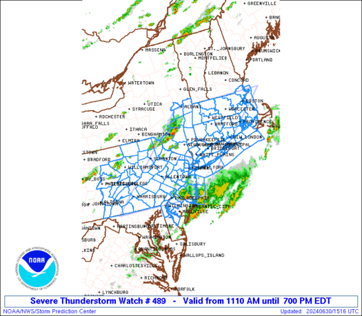
Mesoscale Discussion 1618
NWS Storm Prediction Center Norman OK
0911 PM CDT Tue Jul 14 2026

Areas affected... portions of northern New York into Vermont and New
Hampshire

Concerning... Severe Thunderstorm Watch 489...

Valid 150211Z - 150345Z

The severe weather threat for Severe Thunderstorm Watch 489
continues.

SUMMARY... The severe risk continues over WW489. Additional
supercells and organized clusters moving out of eastern Ontario will
support a continued severe risk into the overnight hours.


